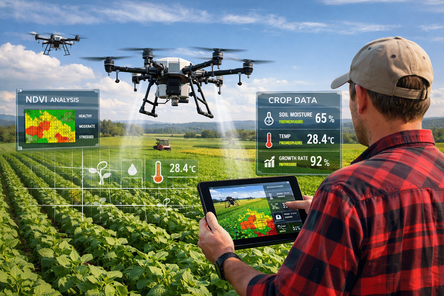
NDVI crop monitoring with drones has changed how farmers manage their fields. We’ve scanned more than 4 million acres of agricultural land across the Midwest and Great Plains through our agriculture drone services. Every project starts with the same question: “Can you fly our fields and tell us which areas have problems?”
The short answer is yes. The longer answer is that NDVI (Normalized Difference Vegetative Index) imaging delivers specific, actionable data about crop health—but only if you understand what you’re looking at and when to fly.
Here’s what you actually get from drone-based crop monitoring, based on real field experience.
What NDVI Actually Measures
NDVI isn’t magic—it’s math based on how plants reflect light.
Healthy vegetation absorbs most visible red light (for photosynthesis) and reflects most near-infrared light (which would otherwise overheat the plant). The ratio between these two wavelengths tells you something about chlorophyll content and plant vigor.
The formula: (NIR – Red) / (NIR + Red)
The result is a number between -1 and +1. Healthy, dense vegetation scores 0.6-0.9. Sparse or stressed vegetation drops below 0.5. Bare soil, water, and dead plant material score near zero or negative.
We capture this data using multispectral sensors that record discrete bands of light — the same sensor technology driving AI-powered analysis across the drone industry—not just “red” and “infrared” but precise wavelengths (typically 650nm red, 840nm NIR) calibrated against reference panels before each flight.
What NDVI Shows You
Vegetation density and vigor: The most straightforward use. Dense, healthy crops show up bright green/yellow on NDVI maps. Thin, stressed, or damaged areas appear orange/red.
This tells you where to look, but it doesn’t tell you why. A low NDVI score could indicate drought stress, nutrient deficiency, disease, insect damage, compaction, drainage problems, or equipment malfunction during planting. The NDVI map shows you the symptom—you still need to walk the field or pull soil samples to diagnose the cause.
Emergence and stand uniformity: Early-season NDVI (V2-V4 growth stage for corn) identifies germination problems, planter skips, and uneven emergence. If you’re seeing low-NDVI stripes across a field in early June, that’s probably planter issues—mechanical problems with seed meters, down pressure, or closing wheels.
We’ve identified planter problems on 50+ farms over the years, often on equipment the farmer thought was working fine. The data is objective—when one row unit is consistently showing lower emergence than adjacent units, you have a hardware problem to fix before next spring.
Mid-season stress detection: NDVI flown at V10-VT (late vegetative through tasseling) identifies stress before it’s visible from the road. Drought stress, nitrogen deficiency, and disease pressure all reduce chlorophyll content before you see visual wilting or color change.
The key is timing. If you fly after the problem is obvious from the cab of a truck, you’ve missed the intervention window. NDVI is most valuable when it tells you something 7-14 days before you would notice it otherwise.
Yield prediction and variable rate mapping: Late-season NDVI (R3-R5 reproductive stages) correlates with final yield in most crops. High-NDVI zones at this growth stage will outyield low-NDVI zones, barring late-season disasters.
Paired with AI-powered analysis, this data drives variable-rate harvest planning (combining poor-yielding areas separately to avoid contaminating high-quality grain) and next-season management decisions (variable seeding rates, fertility adjustments, drainage improvements).
When to Fly
Early season (V2-V4): Checking emergence and stand establishment. We typically fly 3-4 weeks after planting, when problems are fixable via replanting or targeted herbicide applications.
Mid-season (V10-VT): Peak growth monitoring, stress detection, nutrient deficiency identification. This is the highest-value flight timing—you can still intervene with supplemental nitrogen, fungicide applications, or irrigation adjustments.
Late season (R3-R5): Yield prediction and harvest planning. You’re not going to fix problems at this point, but you’re gathering data for next year’s management decisions.
Post-harvest: Residue analysis and field condition assessment. Not every operation requests this, but it’s valuable for identifying drainage issues and planning fall tillage or cover crops.
Flight Parameters That Matter
Altitude: We fly agricultural missions at 300-400 feet AGL, which delivers ground sample distance (GSD) of 2-3 inches per pixel. That’s enough resolution to identify individual plants in row crops while still covering ground efficiently.
Higher altitudes reduce resolution but increase coverage rate. Lower altitudes improve resolution but dramatically increase flight time and data volume. 300-400 feet is the practical sweet spot for most crop monitoring.
Overlap: 75% frontal overlap, 65% side overlap. This ensures we’re not missing data between flight lines and gives photogrammetry software enough overlap to create clean orthomosaics.
Time of day: Late morning to mid-afternoon (10am-3pm) delivers consistent solar illumination and reduces shadow effects. Early morning and late afternoon create long shadows that complicate analysis.
Weather: Clear or high overcast conditions. Broken clouds create moving shadows that cause dramatic variations in reflectance data across a single field. We reschedule if we’re seeing patchy clouds during flight time.
Data Processing and Delivery
Raw multispectral imagery is useless without processing. We use Pix4DFields and DroneDeploy for most agricultural processing, which handles:
- Radiometric calibration: Converting raw sensor values to standardized reflectance using pre-flight reference panel captures
- Orthomosaic generation: Stitching hundreds of images into a single georeferenced map
- Index calculation: Computing NDVI, NDRE (Normalized Difference Red Edge), and other vegetation indices
- Zoning and statistics: Creating management zones and calculating area statistics for each zone
Typical deliverables for a 500-acre farm:
- NDVI orthomosaic (GeoTIFF format for import into precision ag software)
- Management zone shapefile (3-5 zones based on NDVI clustering)
- Zone statistics report (acreage and NDVI statistics for each zone)
- Annotated findings report with areas of concern flagged
Turnaround time: 3-5 business days from flight to final deliverable.
What NDVI Doesn’t Tell You
Why vegetation is stressed: NDVI shows you where problems exist, not what’s causing them. You still need boots-on-ground scouting, soil tests, and tissue samples to diagnose root causes.
Crop-specific issues: NDVI doesn’t differentiate between corn and weeds—it just measures “green vegetation.” In fields with heavy weed pressure, NDVI might look great while your actual crop is suffering.
Soil properties: NDVI measures plant health, not soil conditions. Compaction, pH problems, and nutrient deficiencies show up indirectly through their effect on vegetation, but you can’t diagnose soil issues from NDVI alone.
Small-scale variability: At 2-3 inch resolution, we’re identifying problems across 10+ foot sections of field, not individual plants. If you need plant-by-plant phenotyping, that requires ground-based sensors or very low-altitude flights with specialized equipment.
Integration with Precision Ag Systems
The farms getting the most value from drone NDVI are integrating it with existing precision agriculture data:
- Yield maps: Comparing NDVI data against historical yield data to identify which stress patterns actually affect final production
- Soil maps: Overlaying NDVI with soil survey data to separate soil-driven variability from management-driven problems
- As-applied maps: Checking whether fertility or chemical applications went where they were supposed to
- Weather data: Correlating NDVI patterns with rainfall distribution and temperature stress
Standalone NDVI maps are interesting. NDVI integrated with multi-year field data is actionable.
Real-World Example: Nitrogen Deficiency Detection
Last season we flew 1,200 acres of corn in central Illinois at V8 growth stage. NDVI showed distinct yellow-green zones in the northwest corner of three adjacent fields—about 85 acres total showing values of 0.45-0.55 while the rest of the field was 0.65-0.75.
The farmer walked those zones and confirmed the visual symptoms matched nitrogen deficiency, not drought or disease. Tissue tests verified low N status. He applied 40 lbs/acre supplemental nitrogen to the affected areas.
At harvest, those areas yielded within 8 bushels of the rest of the field. Without the early NDVI detection, he likely wouldn’t have noticed the problem until V12-VT when correction is less effective, and he estimates he would have lost 20-30 bu/acre on those 85 acres.
That’s 1,700-2,550 bushels saved, worth roughly $8,000-$12,000 at $5/bushel corn. The NDVI flight cost $1,800. The supplemental nitrogen application cost about $2,500. Net benefit: $3,700-$7,700.
That’s the value proposition when the timing is right and you act on the data.
Getting Started with Drone NDVI
Most farms benefit from 2-3 flights per season—early emergence check, mid-season vigor monitoring, and late-season yield prediction. Costs run $3-$6 per acre depending on total acreage and flight frequency.
If you’re already running precision ag equipment (variable rate planters, yield monitors, soil sampling), adding drone NDVI data gives you another layer of field intelligence. If you’re not doing any precision agriculture yet, NDVI alone won’t transform your operation—you need the infrastructure to act on variable-rate data.
Get crop monitoring pricing for your operation →
Related Reading
- AI in the Drone Industry: How It’s Actually Being Used — How AI turns raw NDVI data into actionable recommendations.
- Drone Inspection Cost vs Traditional Methods — Cost comparisons across all our inspection services.
- How Drone Cell Tower Inspection Works — See how we apply the same systematic approach to infrastructure.
Ready to schedule crop monitoring flights? Contact us →